We are at home now for Christmas and I had a little time to go over our logbooks. I know some of you are interested in numbers, so here are some of the important ones. The engines have run 275 hours each and we have traveled approximately 2200 statute miles. So the average speed is somewhere around 8 mph. We have burned 992 gallons of diesel at an average price of around $4.00 a gallon. A rough estimate of the mileage is a little better than 2 mpg.
We have anchored 20 times and stayed about 56 nights in a marina with 1 overnight on the boat while crossing the gulf. We would not normally have stayed that many nights in marinas, except that the AGLCA meeting at Joe Wheeler took a few, The visit to Chattanooga took a few, and the week at Mobile getting the prop repaired and visiting New Orleans added to the total. So far we have not paid more than $1.50 per foot (boat is 40 ft) per night. The marina at Pensacola was only $.50 per foot and others were only $.75 a foot. We are getting to the area in Florida where the average price starts at $2.00 a foot and up and can expect to pay that or greater from here until we leave Florida. That means we will probably spend a few more nights on the hook (anchored).
So far the engines have only used 2 quarts of oil, but I need to do an oil change when I get back and that will take 26 quarts for each engine. Glad I only need to change that every 250 hours! Chased a pesky coolant leak on the starboard engine for weeks, and I think I finally have it fixed. New hoses, new radiator cap, and a few extra clamps seem to have it slowed down a lot.
Leaving for the boat on the 1st and should be back there late on the 2nd. Need to change the oil, visit the customs people to get a document to let us get back into the states easier when we visit the Bahamas, buy a Sojourners permit to allow us to stay in Florida over 90 days and re provision for the trip to the Keys. We will probably return the rental car and leave Gulfport on the 4th if everything goes right.
Sunday, December 30, 2012
Monday, December 17, 2012
Tarpon Springs to Gulfport
We left Tarpon Springs a day after Gemini Dream. On the way out of Tarpon we stopped and bought fuel at a commercial dock. They sell a lot of fuel to fishing and sponge boats, so the price was a lot better than we had been seeing. I usually don't let the tanks get below a half and when we reach a place where the price is under $4 a gallon I usually fill up. They even gave me a better price if I would use my debit card instead of a credit card, so I saved an additional 7 cents or so per gallon.
 |
| One of the many bridges crossing to the islands |
 |
| This is what crab pots look like out of the water. Wonder how many he lost!! |
 |
| Waterfront property |
Cindy's Observations: It was the weekend so there were a lot of recreational boaters out enjoying the day. There appeared to be a party on the pirate ship. Reminds me of Captain Tim's ship on the Illinois river at Grafton.
 |
| Idle speed - No Wake!! |
 |
| ARR Tourists!! |
 |
| We made it under this one with the antenna down. |
Cindy's Observations: Here is the bridge entering to Treasure Island. This day was never going to end. It seemed to take forever to get to Gulfport.
 |
| Golf Course |


 |
| Entrance into Gulfport Municipal Marina |
Cindy's Observations: That first night we watched as the boats paraded past us with all their Christmas lights a glow. Sailboats make a grand display with strings of colored lights on the rigging. There were 29 decorated boats in all. The next day we walked into town for lunch at O Maddy's.
Gulfport was a finalist as a Best Food Town in Rand McNallys 2011. At the end of the city pier were anglers fishing for flounder using cut up squid for bait.
On the Gulfport Pier, which was dedicated to the Space Shuttle Challenger and its crew in 1987, were concrete benches in the shape of giant cleats. How fun.

In the park was an interesting ground sun dial shaped like a T. Step stones with months carved on them running north to south is where you stand to cast your shadow over the top stones, running west to east with hours carved on them. it was very accurate. Little lizards were sneaking around us on the sidewalks. The next day we did all the laundry and prepared for departure.

 |
| Gulfport Sunset |
We will be back in early January to start off again. The boat is in a slip that we can monitor with the Marina's TV camera. Go to www.mygulfport.us/City_Departments/Marina/Marina_Web_Cam.htm and see if you can spot it. You may need to load the software that they provide to be able to control the camera.
Port St Joe to Carabelle
There had been fog every morning for the last two days. The forecast for the morning was for dense fog until around 9. This could be a problem. We have about 50 miles to go to get to Carabelle, FL. We got a call from "Help me Rhonda" who is already at Carabelle, and they want us to travel with them across the gulf to Tarpon Springs along with another boat "Blewgrass".
Cindy's Observations: Port St. Joe which is nicknamed the Constitution City is the largest city in Gulf County. While here we watched the process of clams and oysters being scraped off the pilings in the harbor. Dinghies will get punctured and gel coats can be scratched if these shells are not routinely removed. Along the beach I found some nice scallop shells.
While here we reunited with fellow loopers and met some new ones. We had discussed crossing and planned on crossing with 2 other boats from Carabelle
They say there is safety in numbers, so we were pleased to hear we had a flotilla of 3 for our crossing. This would be our last relaxing day prior to crossing.
 |
| Port St Joe |
 |
| Abandoned sailboat aground at Port St Joe |
Woke up early to check the weather and it was beautiful!! The fog did not materialize!! We got ready and headed out. We were following another looper (Prime Time) out, but they were traveling faster and stopping at Apalachicola. Since we got an early start, I throttled back to save a little fuel. We traveled about 7.5 mph today and the engines just sipped fuel. When you went below, the engines sounded like sewing machines just humming away and not hardly working at all.
 |
| Entrance to Lake Wimico from the ICW |
Cindy's Observations: Larry had been price shopping for the auto pilot. He was excited when it all came in under his budget. Any gadget that makes his life easier on the boat is "priceless."
Along this stretch were several nice private homes with lift docks. Quite a few vividly colored A frames, ranch style and two-story houses provided a break in the shoreline. Palm trees and live oaks with Spanish moss are the most common trees. Long needle pines are dotted in the landscape and make terrific mulch for the beds. Betty L had told us to be on the look out for an eagles nests here, which we did see, however, its difficult to zoom in enough for a picture. Likewise with the eagle itself, too hard to capture with the camera. We were able to make lasting memories in spite of no pictures.
I saw on the charts that there was a railroad bridge with an 8 ft clearance just this side of Apalachicola that you need to call for an opening. Luckily the bridge was already open so I didn't need to call them. In fact it didn't look like the bridge had been closed in a long time. The charts that we are using are somewhat dated but the price was right and what is the chance of them moving the waterway or cities? We found a few bridges that were not on the charts, and a few that were on the charts but nonexistent, but that presented no problem. I usually cross check the paper charts, my plotter charts, and the Skipper Bob cruising guide to keep up with everything and not have too many surprises.
Cindy's Observations: Knowing past loopers is a great advantage when it comes to charts needed for the journey. We sent a donation to Pats uncle and aunt for sending their charts to us. Tumble Weed has graciously loaned us his charts till our journeys end. Like Larry says, the rivers and channels do not change. We use a combination of charts, guide books and waterway guides published by the corp of engineers. Plus word of mouth from fellow loopers. Blogs are the more preferred method for AGLCA members.
 |
| Railroad swing bridge |
When we left lake Wimico we entered the Apalachicola River which we followed all of the way to Apalachicola. At Apalachicola we entered into Apalachicola Bay and were pretty much in open water from there to Carabelle. We had a few Porpoise follow along for the ride and saw a lot of small boats that were getting Oysters off the bottom in the shallow areas. The Bay was large, but you needed to follow the charted course because it did get shallow in places. Those places are abundant with Oysters, A taste for which I haven't quite acquired. Fried yes, Broiled yes, but raw - not quite yet. Maybe by the time we are ready to leave Florida I will have tried them at least once.
Cindy's Observations: Porpoise always get our attention and keep us alert. Mommas with babies are the more favored to watch. The playful ones will do an out of the water jump and splash. When we are anchored and the dolphins surface, you can distinctly hear the forceful exhale from their blow hole. Baby dolphin are born live about half the size of the mother and stay with her for 4 years. The pod feeds twice a day, am and sunset by swimming in a large circle forcing fish into the center and closing the circle for a mass feed.
 |
| Apalachicola Bay (with porpoise) |
 |
| Bay water is not as clear |

 |
| Harvesting Oysters |
 |
| Bridge over Apalachicola Bay |
Cindy's Observations: Apalachicola was once the 3rd largest port on the gulf of Mexico founded in 1831 with cotton and lumber being its largest trade. Today it harvests more than 90 percent of the states oyster consumption. Another fact of Apalachicola is during the time of yellow fever a former mayor, Dr. John Gorrie, developed and patented an ice machine to keep the ill comfortable in a cool room. He was the pioneer for air conditioning and refrigeration.
There were several oyster boats in the bay collecting oysters with a long handle type of rake called "tongs." One person stands and collects , the other person sits and "culls." Too small and the dead ones are thrown back. This practice has been ongoing for over 100 years.
Leaving Apalachicola Bay, we immediately came into Carabelle. It's basically a fishing village and nothing very special for tourists. Cheap fuel and a place to wait out the weather for a smooth crossing.
 |
| Carabelle Harbor |
 |
| Carabelle |
 |
| Law enforcement is serious here |
 |
| The Moorings at Carabelle |
We went to eat at a local restaurant (only one in town that was open and within walking distance) and settled down for hopefully a good nights rest. It was really hard with the anticipation of what was coming the next day. The part of the cruise that we had been dreading since before we left!!
Cindy's Observations: Ok so now I am getting anxious and nervous, can't really say excited about the crossing. We know it may or may not be a pleasant experience, but all things look good so far. The seas were forecast to be calm. For this time of year it was unusually mild and calm this many days in a row for December. Before dinner we had a briefing with 3 couples, two from Blewgrass on their boat and one couple from Help Me Rhonda discussing the route. After the briefing we met the two couples from Blewgrass at The Fisherman's Wife restaurant. We were all geared up for the next days adventure. In the morning I took a glimpse at the two more interesting features of the town.
 |
| WW II Museum |
 |
| Carabelle Police Station |
Cindy's Observations: Carabelle was first known as "Rio Carabella," meaning beautiful river. It is located on the southwestern tip of St. James Island.
Back in 1942 to 1946 Camp Gordon Johnston trained 250,000 WWII soldiers for amphibious landings and shore combat. The landscape on the island provided the terrain needed for foot soldiers and Dog Island met the demands for the WWII DUKW amphibious landings.
Here you will also find the "Worlds Smallest Police Station." A 1960 phone booth.
Sunday, December 16, 2012
The Crossing
We stayed at The Moorings overnight. Before we had arrived there, Wayne, on Help Me Rhonda, had been talking to the local expert "Buddy". He said that we should leave that afternoon. I could not do that, I had been up all day and staying up another 20 hours or so would not be possible. I had my doubts about Buddy's creditability, because his suggestions did not quite go along with Tom (the weather guy) that posts a daily column on the AGLCA website. Tom suggested leaving later in the afternoon and going direct to Tarpon Springs at a slow speed arriving at 10 in the morning when the sun was not in your eyes. Tarpon Springs is well known for the numerous crab pots and their floats. If you snag one of the floats in your prop, you immediately wrap up the rope pulling the crab pot off of the bottom and into the bottom of your boat. Then you cannot run that engine until you free yourself from the rope and hopefully have not done any damage to the propeller or the strut that supports the propeller shaft. Not a pretty sight to be in the Gulf and not be able to use an engine or both engines if you were really unlucky.
We finally agreed to leave the next morning at around 11:00 AM and head toward Tarpon Springs, but not go directly there, The plan was to head east and follow the curve of the mainland south while staying far enough offshore to stay in deeper water and away from the crab pots. Buddy told us that the crab pot problem was overrated, He said that for every boat that hit a crab pot there were thousands that did not, and therefore they were really no problem at all! Remind me to give you my theory on this later. The problem with this, is that leaving so early we would get to Tarpon Springs about sunrise, not a good plan in my mind, but what the heck, the crabpots are not a problem, right??
Next came the selection of who would lead. Blewgrass had 4 crew, but no autopilot, and I gather, not a lot of experience. But, they did have AIS! Help me Rhonda had more experience, no AIS, and an autopilot that could not follow a plotted course, but sometimes would follow a heading if everything was perfect. That left us, with 3 crew, experience questionable (especially in Gulf crossings), good autopilot, AIS, and not smart enough to say no!
We led the pack out of the Marina at around 11:00 AM and I set the autopilot for the first waypoint. We had all agreed on the waypoints and had all entered the same ones, so that we would all be on the same page when we decided to do any changes. That's when the plan changed for the first time of many. We were getting 2 ft seas from the starboard beam. While not bad it was uncomfortable. The boat was rolling a bit, and we all agreed that if we changed course to a more southerly waypoint it would be a lot better. The down side, if any, would be that we would now arrive at Tarpon Springs even earlier. Now it wouldn't even be light enough to see those pesky crabpots. But, change we did!!
 |
| Sunshades keep the sun off the display |
 |
| A little rough when we started |
 |
| Crew resting in the sun |
Cindy's Observations: Pat was able to catch some winks that afternoon. Around 4 o'clock I tried to sleep in the chair but opted to go on the bed below . Just at dusk I was brought to my feet by a hellatious sound. My fears were we had caught a crab pot and had some damage. I ran topside to get the report. There were crab pots beside us but Larry cut the engine and threw it in reverse to avoid a snag. That is what the noise was that scared the wits out of me. He assured me there was no problem of any kind.
The sky was bright and sunny when I went below, now it had transformed to an eerie dense air and unsettling layer of fog hovering below the clouds. Even though the water was as calm as it could be, I had an uneasy feeling something was going to happen. The sunset was pretty. We even had a pod of dolphin doing acrobatics in the distance. But I still felt uneasy.
 |
| Calm Seas |
 |
| Calmer seas |
 |
| Sunset |
 |
| What I saw as the night went on |
Cindy's Observations: As it got darker, the lights on the boats behind us began to take on the shape of Christmas trees. I used this analogy to try and settle my nerves. Even the instrument panel looked of Christmas. We all wished the smooth as glass water would last through the night. At this point Pat issued the life jackets. I chose the older vest type for two reasons: warmth and padding. Larry and Pat followed suit. If we were going to run into rough water the padding would be appreciated.
 |
| Water like glass!! |
 |
| Help me Rhonda and Blewgrass at night |
The sky was cloudy so there was no moon or stars. As we continued on, you could not see the water or the horizon. The boat steadily increased it's rocking until at one point around 2:00 am, both Cindy and Pat were knocked off of their chairs by a wave. Pat's completely came out from under her and folded up, leaving her sprawled on the floor on top of the collapsed chair. She got a pretty bad bruise from it too. Cindy ended up on the floor next to my chair and just stayed there. It was safer to not move. We had all agreed when we left, that we would all wear life jackets all night no matter what the conditions, so we just settled in where we were.
Cindy's Observations: Around 10:30 Larry and Pat had a snack. My stomach felt a little queasy because I hadn't eaten enough earlier that day. I ate a little thinking it would settle my stomach. As the waves increased the breeze did too. Since we did not have any moonlight it was difficult to judge time. Around 2 am Pat and I simultaneously were bounced out of our seats onto the floor. As Larry says, it was the safest place to be.
The wind had picked up again and now was hitting us from the port side. We were heading south by now, so to get away from the pounding we were taking on the beam (side), we either had to turn east towards shore and head into the waves, or turn more southwest away from shore and take the waves on the port quarter. By this time we had switched places and Help Me Rhonda was in the lead with us following directly behind them and Blewgrass following us. Wayne looked at his charts, I couldn't catch mine, they were all over the boat because of the big wave, and I couldn't focus on the chartplotter because it was bouncing so bad. We decided that if we went toward shore, we could stray into some shallow water and more crab pots. So we turned more out to deeper water away from shore.
About this time we lost Blewgrass!! Not really lost, but left behind a little. Being a single engine trawler, she was taking a little worse beating that us. When we decided to turn more out to the Gulf, she slowed way down. Our boat will idle around 6 mph which was faster than Blewgrass wanted to go. We kept them in sight for quite a while, but lost sight of them close to daylight. We kept in contact by radio and I relayed heading and waypoint information to them as we went.
Cindy's Observations: We felt bad pulling away from Blewgrass but we couldn't go any slower. Our focus at that point was to watch for crab pots. There were a lot out there. Several strings running in different directions. I was in the front window with the glass up, Larry's at the wheel watching and Pat was watching out the sides. As the sun started to lighten the sky the waves seamed to be letting up slightly.
We continued on until daylight, which was around 6:30 in the morning. The higher the sun got, the better you could see the crab pots, which had been with us pretty much all night I'm sure. So as wrong as Buddy was on the weather, he seemed to have been right about the crab pots. We weaved our way through them as they came into view. If you were watching those that were near the bow of the boat as we went buy, you could see that the same bow wake that propelled the porpoise along under the boat, was pushing the floats out of the way!! I still paid attention to them, but was not nearly as concerned as before.
Cindy's Observations: Like the colors of jockey's silks on horses the crab trap floats have colors and bands to designate the fisherman's traps. Some had 1/2 color 1/2 white or a color band. The gray floats where very difficult to spot. We thought it would be wonderful if the floats had reflective qualities to spot them easily.
 |
| Float on a crabpot!! |
As we got west of Tarpon Springs, we turned east and headed into the channel leading into port. If there had not been the cloud cover, we would have been looking directly into the sun, However, the rest of the trip was pretty easy. The water was calmer and the crab pots were visible and everyone was wide awake again. I relayed the Lat Long of the turn to Blewgrass so she could mark the spot on her plotter and know where to follow.
 |
| Following Rhonda east into Tarpon Springs 0700 |
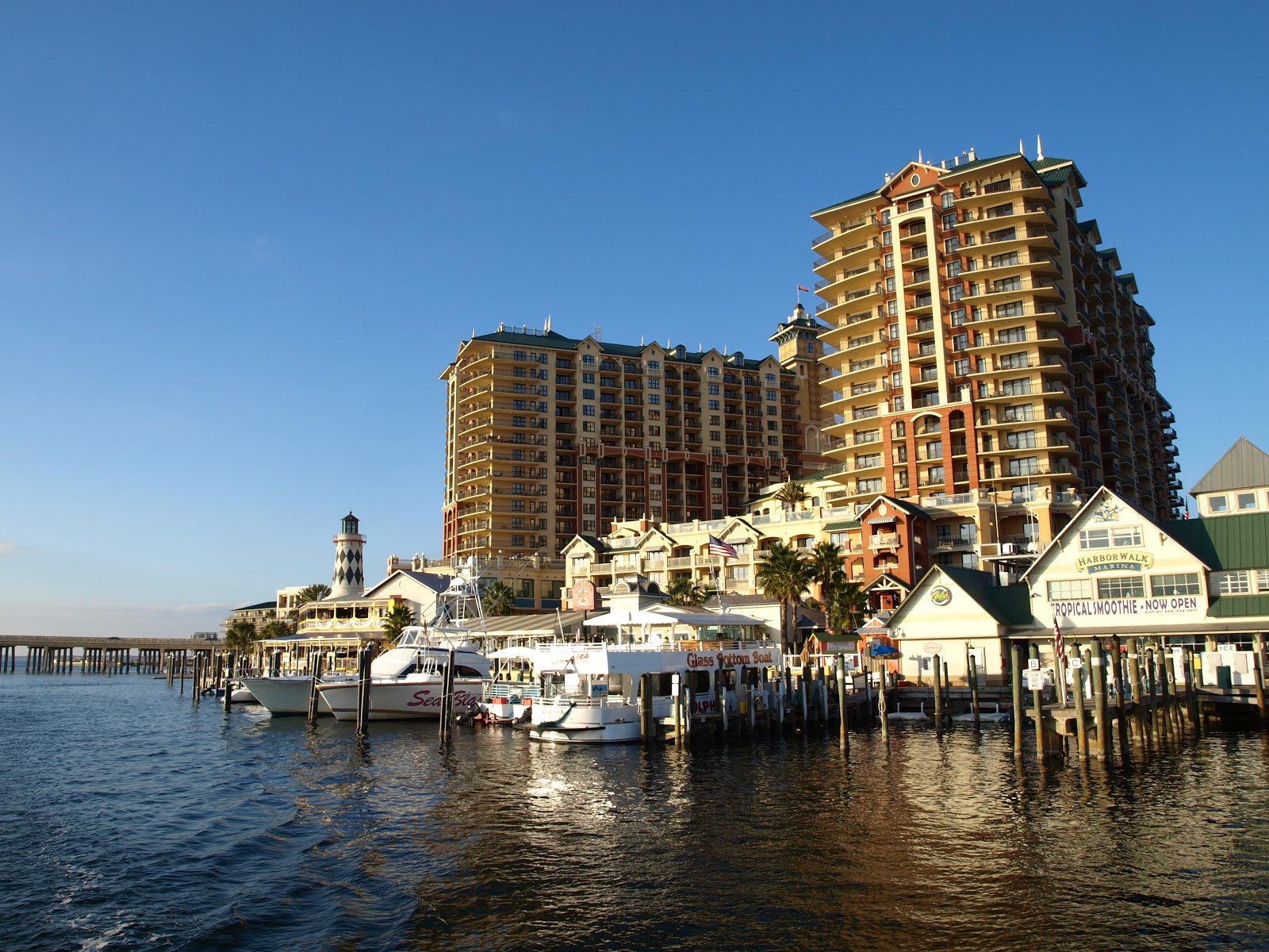
We had two plans as to what we were going to do once we got into protected waters again. One was to find a quiet place to anchor and sleep for a couple of hours and then get to our slip at the Tarpon Springs City dock. The other was to just continue on to the City dock and be done with it. We decided to keep going and got to the city marina around 9:30. We had put around 23 hours on the engines since we left Carabelle, and no sleep at least for me! Later when I filled the tanks, I found that we had burned around 90 gallons of fuel and travelled around 181 statute miles. Pretty close to 2 MPG!! Pretty good for our size of boat. We averaged just a little over 7.8 Mph. Pretty slow, but efficient.
And guess who greeted us at the dock and helped us tie up?? Gemini Dream!! She had taken the more puppy friendly long way around the bend. Having originally left Apalachicola for Cedar Key, they found the water too shallow and continued on to Crystal River and followed the coast for 2-3 days anchoring along the way and got to Tarpon Springs the day before us. So we had another happy reunion.
Cindy's Observations: After Larry hailed the marina for our slip assignment, a familiar voice came back to give us instructions how to enter the channel. It was a pleasant surprise to hear Gemini Dream on the radio. We tied up next to them and gave them a big "we survived our cross" hug. After our hellos Larry went down for a nap. Pat and I had a bite for breakfast. Pat went to bed soon after. I was too keyed up and wide awake to sleep. I went shopping on the sponge docks.
Tarpon Springs is a Greek city with Sponge diving boats, Greek food, and Sea food galore.
Cindy's Observations: Tarpon Springs was once called the "Venice of the South." It is known as the "Sponge Capital of the world." It received its name for the giant Tarpon that jumped and splashed in the bayou in 1876. The spring water here was considered to have healing powers It is now a prime spot to watch manatees. The Greek divers came to Tarpon Springs and discovered the wealth of sponges. Soon the community grew to what it is today, a thriving Greek culture within the community.
After a good nights sleep, we felt a lot better.
Cindy's Observations: It is only a guess as to which is the best way to cross the gulf. You can only hope for the best conditions. Given the opportunity to cross again, we would choose a shorter daytime cross with FLAT water.
Tuesday, December 11, 2012
Pensacola to Port St Joe
We left Pensacola along with Gemini Dream, who had caught up to us there. We left for separate anchorages on the way to our destination at Port St. Joe. We had selected a nice secluded anchorage next to one of the islands that is located just off of the intracoastal. Gemini Dream had selected one a little closer that was "puppy friendly" which means that there is a place to go ashore and walk the dog. The one we selected was next to some property that belonged to a nearby Air Force Base and they discouraged people coming ashore with pets.
As we got closer to the anchorages it was still early, so we pressed on toward Destin, Florida which had both a nice anchorage and was "puppy friendly". We were getting hungry as we arrived at Ft Walton Beach so we stopped at a "waterside" restaurant and had lunch. They had a dock, but there was a tremendous tidal current. Gemini Dream docked so the current pushed them to the dock, but we had to fight both the wind and current to get to the dock, then it was a little tricky getting tied up. At least when we left, we only had to release the lines and we were away for the dock. We went a few miles further and anchored in Destin Harbor. It was very commercial and I'm glad it was not in the summer because it looks like a very popular area for tourists. I guess the Jetski's drive you crazy in the summer. It was very quiet for us though that night.
Cindy's Observations: This was a first for us, stopping for lunch. We usually had a snack, or some type of lunch food while underway. So this little French cafe was definitely a treat. While there, we talked with a couple who was wintering at a condo at Destin where we were to anchor. They knew of the place we were told we had to go visit, "The Boat House" oyster bar.
Destin is called Florida's Emerald Coast with miles of sugary sand made of Appalachian quartz. It is also known as the The Luckiest Fishing Village in the world.
Arriving into the bay by porpoise escort (they're so friendly) was this amazing tiny Lake of the Ozarks on steroids, with much deeeeper pockets. I marveled at all the yacht size boats and multiple condo plexes packed around this bay. Summertime here would definitely be a buzz for all the party hardy types.

We dinghyed ashore and found a seafood place (what else) and had a few oysters and some cocktails and came home in the dark.
Cindy's Observations: After we dropped the hook and settled, the couple from the cafe came by on their boat (Judy B) from their condo to wish us a safe trip and to enjoy our evening ashore. First we took a dinghy ride to the beach and watched the sunset. Across the beach was the open gulf. Soon we would be out there to make our cross. We made it to The Boat House after sunset and had our oysters and a drink. The walls and ceiling and just about any flat surface were covered in dollar bills from all the patrons. There is another sister Boathouse oyster bar in the keys in which we hope to stop.


After a quiet night we left for Panama City and another anchorage. Matt and Coleen showed us how much faster we could get there if we went "outside" which means leave the safety and calm water of the ICW (intracoastal waterway) and go out a pass into the Gulf. We agreed to try it and just see what the seas were like "outside". We followed Gemini Dream out the pass and got bounced around so bad that I decided that we were not going to do this, at least not today. Gemini Dream turned around also and followed us back into calm water. They still believe that it would have gotten better if we had gotten away from shore a bit, but we had already had everything come off of the shelves down below. Pat was below when we went out and just sat down in the middle of the salon floor to dodge flying objects.
Cindy's Observations: A wise sailor had warned us, "When you look out to sea and see elephants on the horizon, do not go out." BELIEVE THIS TO BE TRUE!!! What we had experienced at Mobile was less pounding than what we had now. When our table tips over top side we have 3-4 foot waves this we have learned quickly! Matt was assuring us once we got passed the shallow shore line the waves would lighten up. After just 20 minutes of pounding we decided to opt for the inside route.
We took the long way around through the ICW and passed through a couple of large bodys of water and saw a lot of Porpoise, and Cindy got some of the best pictures yet of them swimming beside the boat.
Cindy's Observations: In order to get these shots, I was hanging over the bow sprit rail. The camera was held down below me. This fellow was joy riding directly below the bow dead center. When they swim beside the boat in your bow wake, they actually turn their head to look at you. It makes you wonder if the legend is true about sea captains spirits and porpoise.


Coming into Panama City I picked up a Navy ship of some kind on my AIS. When we looked in the general direction of the target, we saw this tremendous wake. Bigger than any we have seen from any SeaRay. (SeaRays are notorious for big wakes and being very inconsiderate around other boats) As we were preparing to get rocked, he called us and told us he would go "slow bells" until he passed us. We sure were glad of that.
We anchored just off of one of the barrier islands south of Panama City. We dinghyed to shore with Gemini Dream so they could walk their dog. The sand was a beautiful white color and very fine. It even squeaked when you walked on it.
Cindy's Observations: Shell Island is a must see stop from Panama City. It is a 700 acre barrier island for wildlife refuge of native animals. It has the worlds largest bottle nose dolphin population off shore. This was our 1st beach for collecting a few sea shells. On the beach edge we saw several sea urchins. Because the sand is so white it will not burn your feet in the heat of summer. Do to the clean quartz crystals it squeaks when you walk. We watched the sunset on the beach and were invited for dessert onto Gemini Dream. The day ended on a sweet note.
The next morning Gemini Dream said they were going "outside" to Apalachicola. We were only going to Port St. Joe but could have followed them as far as there and let them continue on, but the memory of the pounding that we took the day before convinced us to again stick to the ICW.
So we parted ways with Matt and Coleen (again) and they took off for deep water and we continued to follow the lazier prettier route along the ICW.
Cindy's Observations: This is Gemini Dream in "Blue Water" on the outside of the GIWW. The chain of islands along the coast is what creates the ICW or GIWW (intracoastal waterway, gulf intracoastal waterway). Until we have to make our cross from the pan-handle to the western shore, we will stay in the ICW. As you can see the sand is so white , it looks like snow.
Along the way, we caught up to "the girls" as everyone refers to them. They are on a small sailboat. We had first met them in Grafton before we left. Cindy has been communicating with them by text as we went along. They anchor a lot more than we do. I suspect their budget requires it. They are college-age girls out on an adventure.
Cindy's Observations: These young gals have got it going on. Kudos to them on such an adventure. Their parents should be proud. They started in the great lakes. Since Chicago has a low bridge no sailboat mast can go under, their mast was stepped and shipped to Mobile, AL. It was stepped there to be able to sail again. This day there was not enough breeze for them to set sail. They too will be crossing the big bend and we wish them calm seas with a "mild" breeze for sailing. They also have a dog and cat aboard.
On the way back from Chattanooga we stopped at Ditto Landing. Next to us was a trawler that was planning to leave Ditto Landing and go pick up his sail boat and take it to the gulf. We met him on the way to Port St. Joe, and sure enough he had the sailboat with him tied to his starboard side. We gave him a slow pass to make sure we didn't disturb his "tow".
Cindy's Observations: John from Emery EL was a wealth of information when we chatted at Ditto Landing. We received good info about local businesses, anchorages and marinas from there to the Black Warrior river.


We spent 3 good days at Port St Joe. Pat had won a free week there. We found a sporting goods store that had diving gear on sale. Pat and I bought new BCD's that were on sale, and I bought a wetsuit. They also had a wet suit that fit Cindy, so we got it in case she decides to try snorkeling.
Cindy's Observations: Pat won the week with a bingo card at Joe Wheeler.
Hopefully this suit will make a more pleasant snorkeling experience. My last try was in the BVI with a sinus infection and rented equipment. Not good.


.jpg)
Cindy's Observations: Port St Joe is in Gulf county. It was Florida's largest populated county at the time of the Florida state constitution signing in 1838. The states first steam railway came through St Joe and was also one of the first in the country. A few miles away in the 'old St Joseph' Cemetery lie statesmen and the sailor who brought yellow fever to the community which almost wiped out the entire population in 1841. A few years later a Storm came and took out the rest of the town. It has rebuilt to the present location and new name. It was an enjoyable bike ride discovering the towns history. Close to the marina along the bike path was this pond. It called to me so I had to stop and take a picture.
As we got close to the day of crossing the Gulf, we were paying more attention to the weather reports. While we were at Port St Joe, the weather guy on the AGLCA blog posted that there was going to be one of the best crossing windows that he had ever seen in December. Normally the windows only lasted a couple of days, but this one was supposed to last a whole week.
We had considered leaving the boat at Port St. Joe for a month and coming home for Christmas. The only problem was that the weather in January was typically worse for crossing than December. So we decided to leave Port St Joe early and head for Carrabelle to prepare to jump across the gulf to Tarpon Springs Florida before Christmas.
As we got closer to the anchorages it was still early, so we pressed on toward Destin, Florida which had both a nice anchorage and was "puppy friendly". We were getting hungry as we arrived at Ft Walton Beach so we stopped at a "waterside" restaurant and had lunch. They had a dock, but there was a tremendous tidal current. Gemini Dream docked so the current pushed them to the dock, but we had to fight both the wind and current to get to the dock, then it was a little tricky getting tied up. At least when we left, we only had to release the lines and we were away for the dock. We went a few miles further and anchored in Destin Harbor. It was very commercial and I'm glad it was not in the summer because it looks like a very popular area for tourists. I guess the Jetski's drive you crazy in the summer. It was very quiet for us though that night.
Cindy's Observations: This was a first for us, stopping for lunch. We usually had a snack, or some type of lunch food while underway. So this little French cafe was definitely a treat. While there, we talked with a couple who was wintering at a condo at Destin where we were to anchor. They knew of the place we were told we had to go visit, "The Boat House" oyster bar.
Destin is called Florida's Emerald Coast with miles of sugary sand made of Appalachian quartz. It is also known as the The Luckiest Fishing Village in the world.
Arriving into the bay by porpoise escort (they're so friendly) was this amazing tiny Lake of the Ozarks on steroids, with much deeeeper pockets. I marveled at all the yacht size boats and multiple condo plexes packed around this bay. Summertime here would definitely be a buzz for all the party hardy types.
 |
| Tourist attractions |
 |
| Little seafood place where we ate. |
 |
| Almost sunset |

 |
| Destin at Night |
 |
| Gemini Dream at Sunset |
We dinghyed ashore and found a seafood place (what else) and had a few oysters and some cocktails and came home in the dark.
Cindy's Observations: After we dropped the hook and settled, the couple from the cafe came by on their boat (Judy B) from their condo to wish us a safe trip and to enjoy our evening ashore. First we took a dinghy ride to the beach and watched the sunset. Across the beach was the open gulf. Soon we would be out there to make our cross. We made it to The Boat House after sunset and had our oysters and a drink. The walls and ceiling and just about any flat surface were covered in dollar bills from all the patrons. There is another sister Boathouse oyster bar in the keys in which we hope to stop.


After a quiet night we left for Panama City and another anchorage. Matt and Coleen showed us how much faster we could get there if we went "outside" which means leave the safety and calm water of the ICW (intracoastal waterway) and go out a pass into the Gulf. We agreed to try it and just see what the seas were like "outside". We followed Gemini Dream out the pass and got bounced around so bad that I decided that we were not going to do this, at least not today. Gemini Dream turned around also and followed us back into calm water. They still believe that it would have gotten better if we had gotten away from shore a bit, but we had already had everything come off of the shelves down below. Pat was below when we went out and just sat down in the middle of the salon floor to dodge flying objects.
Cindy's Observations: A wise sailor had warned us, "When you look out to sea and see elephants on the horizon, do not go out." BELIEVE THIS TO BE TRUE!!! What we had experienced at Mobile was less pounding than what we had now. When our table tips over top side we have 3-4 foot waves this we have learned quickly! Matt was assuring us once we got passed the shallow shore line the waves would lighten up. After just 20 minutes of pounding we decided to opt for the inside route.
We took the long way around through the ICW and passed through a couple of large bodys of water and saw a lot of Porpoise, and Cindy got some of the best pictures yet of them swimming beside the boat.
Cindy's Observations: In order to get these shots, I was hanging over the bow sprit rail. The camera was held down below me. This fellow was joy riding directly below the bow dead center. When they swim beside the boat in your bow wake, they actually turn their head to look at you. It makes you wonder if the legend is true about sea captains spirits and porpoise.


Coming into Panama City I picked up a Navy ship of some kind on my AIS. When we looked in the general direction of the target, we saw this tremendous wake. Bigger than any we have seen from any SeaRay. (SeaRays are notorious for big wakes and being very inconsiderate around other boats) As we were preparing to get rocked, he called us and told us he would go "slow bells" until he passed us. We sure were glad of that.
 |
| Navy ship at "slow bells" |
We anchored just off of one of the barrier islands south of Panama City. We dinghyed to shore with Gemini Dream so they could walk their dog. The sand was a beautiful white color and very fine. It even squeaked when you walked on it.
Cindy's Observations: Shell Island is a must see stop from Panama City. It is a 700 acre barrier island for wildlife refuge of native animals. It has the worlds largest bottle nose dolphin population off shore. This was our 1st beach for collecting a few sea shells. On the beach edge we saw several sea urchins. Because the sand is so white it will not burn your feet in the heat of summer. Do to the clean quartz crystals it squeaks when you walk. We watched the sunset on the beach and were invited for dessert onto Gemini Dream. The day ended on a sweet note.
 |
| Shell Island |
The next morning Gemini Dream said they were going "outside" to Apalachicola. We were only going to Port St. Joe but could have followed them as far as there and let them continue on, but the memory of the pounding that we took the day before convinced us to again stick to the ICW.
So we parted ways with Matt and Coleen (again) and they took off for deep water and we continued to follow the lazier prettier route along the ICW.
Cindy's Observations: This is Gemini Dream in "Blue Water" on the outside of the GIWW. The chain of islands along the coast is what creates the ICW or GIWW (intracoastal waterway, gulf intracoastal waterway). Until we have to make our cross from the pan-handle to the western shore, we will stay in the ICW. As you can see the sand is so white , it looks like snow.
 |
| Gemini Dream going "out to sea" |
Along the way, we caught up to "the girls" as everyone refers to them. They are on a small sailboat. We had first met them in Grafton before we left. Cindy has been communicating with them by text as we went along. They anchor a lot more than we do. I suspect their budget requires it. They are college-age girls out on an adventure.
Cindy's Observations: These young gals have got it going on. Kudos to them on such an adventure. Their parents should be proud. They started in the great lakes. Since Chicago has a low bridge no sailboat mast can go under, their mast was stepped and shipped to Mobile, AL. It was stepped there to be able to sail again. This day there was not enough breeze for them to set sail. They too will be crossing the big bend and we wish them calm seas with a "mild" breeze for sailing. They also have a dog and cat aboard.
 |
| The girls |
Cindy's Observations: John from Emery EL was a wealth of information when we chatted at Ditto Landing. We received good info about local businesses, anchorages and marinas from there to the Black Warrior river.

Coming into Port St. Joe we passed numerous sunken shrimp boats. Probably from the last Hurricane.

 |
| Fixer-upper |
We spent 3 good days at Port St Joe. Pat had won a free week there. We found a sporting goods store that had diving gear on sale. Pat and I bought new BCD's that were on sale, and I bought a wetsuit. They also had a wet suit that fit Cindy, so we got it in case she decides to try snorkeling.
Cindy's Observations: Pat won the week with a bingo card at Joe Wheeler.
Hopefully this suit will make a more pleasant snorkeling experience. My last try was in the BVI with a sinus infection and rented equipment. Not good.


.jpg)
Cindy's Observations: Port St Joe is in Gulf county. It was Florida's largest populated county at the time of the Florida state constitution signing in 1838. The states first steam railway came through St Joe and was also one of the first in the country. A few miles away in the 'old St Joseph' Cemetery lie statesmen and the sailor who brought yellow fever to the community which almost wiped out the entire population in 1841. A few years later a Storm came and took out the rest of the town. It has rebuilt to the present location and new name. It was an enjoyable bike ride discovering the towns history. Close to the marina along the bike path was this pond. It called to me so I had to stop and take a picture.
 |
| Lilly pond |
We had considered leaving the boat at Port St. Joe for a month and coming home for Christmas. The only problem was that the weather in January was typically worse for crossing than December. So we decided to leave Port St Joe early and head for Carrabelle to prepare to jump across the gulf to Tarpon Springs Florida before Christmas.
Cindy's Observations: After taking pictures of the lily pond I walked along the shore and was able to find some very nice scallop shells for my grand daughters collection. When I realized the setting before me, I thought this would be a perfect place to watch the sunset. So just before the sun set I went back and captured a wonderful shot.
 |
Subscribe to:
Posts (Atom)